 www.cbsnews.com
 By Alex Sundby
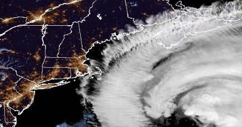
Hurricane Erin threatened the East Coast with dangerous surf and rip currents as the large and growing storm moved on a projected path up the Atlantic Ocean, the National Hurricane Center in Miami said early Wednesday. The hurricane isn’t expected to make landfall in the U.S., but people in North Carolina’s Outer Banks were warned of possible coastal flooding that triggered evacuation orders.
Conditions are “expected to deteriorate along the coast of North Carolina by this evening,” the center said, adding that people “are cautioned against swimming at most U.S. East Coast beaches due to life-threatening surf and rip currents.”
Erin, the first Atlantic hurricane of 2025, was downgraded to a Category 2 storm Tuesday morning as it churned over the Atlantic Ocean north of the Caribbean. It previously exploded to a Category 5 on Saturday before weakening to a Category 3 early Sunday morning, then regaining strength again later in the day. It’s forecast to retain hurricane strength into the weekend…
READ FULL ARTICLE HERE… (cbsnews.com)

Home | Caravan to Midnight (zutalk.com)


