By Tyler Durden
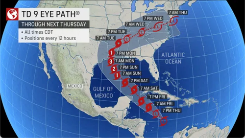
Update (1908ET): Tropical Depression Nine has strengthened into Tropical Storm Ida late Thursday afternoon and is expected to become a major hurricane once it reaches the US Gulf Coast late weekend or Monday, according to the National Hurricane Service (NHC).
Air Force Reserve hurricane hunter aircraft flew into the storm late afternoon and determined “that the depression has strengthened to Tropical Storm Ida,” NHC said. As of the 1720 ET update, the storm has maximum sustained winds of around 40 mph.
520 PM EDT Update: Air Force hurricane hunters find depression has strengthened into Tropical Storm #Ida. https://t.co/4LIsgbp8uT pic.twitter.com/WkPVKhOmKd
— National Hurricane Center (@NHC_Atlantic) August 26, 2021
In a 1700 ET update, NHC said: “portions of the northern Gulf coast, especially along the coast of Louisiana,” could be swamped with “life-threatening storm surge, damaging winds, and heavy rainfall” when the storm makes landfall some time late Sunday or Monday.
Ahead of the storm, energy companies are evacuating their workers from oil and natural gas platforms in the Gulf of Mexico. Bristol Group has been using helicopters for the last few days to retrieve workers from natgas platforms.
Statistically speaking, we should remind readers that the busiest part of the Atlantic hurricane season is already underway, as the tropics are awakening.
National Oceanic and Atmospheric Administration forecasters recently bumped up their forecast to 21 named storms this season.
* * *
AccuWeather forecasters released a weather note Thursday about a tropical disturbance in the Caribbean Sea that has strengthened into Tropical Depression Nine and could become a major hurricane, possibly striking the US Gulf Coast Sunday/Monday.
The forecasters warned the storm could strike parts of the central Gulf Coast as a major hurricane (Category 3 or stronger) on Sunday evening or Monday.
We published a weather note on Wednesday outlining the same system to strengthen and landfall risks from Texas to Louisiana next week.
Fox 8 Meteorologist Zack Fradella told residents of South Louisiana to prepare for a major hurricane:
“We have seen this before. Expect a Cat 3 at the very least,” he tweeted.
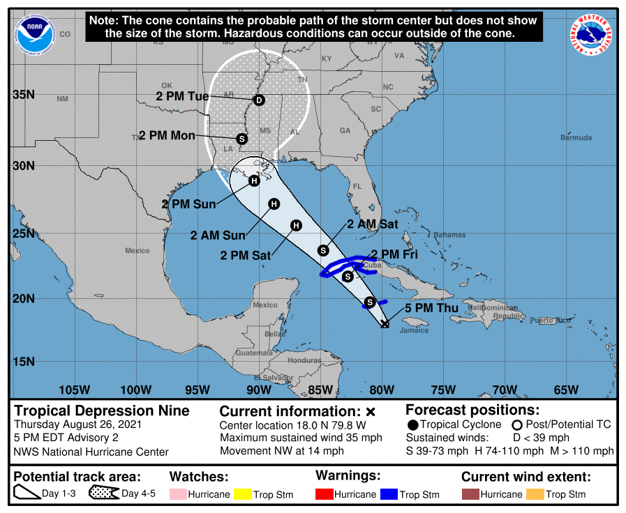
On Thursday morning, the depression was moving at 13 mph and had maximum sustained winds of 35 mph, and was approximately 115 miles south-southwest of Negril, Jamaica. The storm is expected to rapidly strengthen over the coming days when it takes a path over the central Gulf of Mexico.
“The sooner the system strengthens, the more likely it is to take a northwesterly track into the central Gulf of Mexico, rather than a westward track across Mexico’s Yucatan Peninsula and into the southwestern Gulf,” AccuWeather Senior Meteorologist Rob Miller explained.
AccuWeather forecasters say the cone of uncertainty points to landfall from Texas to Louisiana to Mississippi and even Alabama. Across these areas are petroleum assets on land and offshore.

Meteorologist Phil Klotzbach from Colorado State University tweeted Tropical Depression 9 is similar to Hurricane Michael in 2018 and Hurricane Laura in 2020, both slammed US Gulf Coast states.
Tropical Depression 9 has formed in the western Caribbean. The next name on the National #Hurricane Center's list for the 2021 Atlantic season is Ida. The long-term (1991-2020) average 9th Atlantic named storm formation date is 15 September. pic.twitter.com/jm1CeA0Bhk
— Philip Klotzbach (@philklotzbach) August 26, 2021
The next named storms of the 2021 Atlantic hurricane season will be Ida, Julian, and Kate. Readers should continue to monitor the storm through the weekend for updates on the landfall area.


