A half-foot or more of rainfall is possible between coastal Louisiana and the Florida Panhandle this weekend
The uptick in tropical activity foreshadows what many experts are predicting to be an active hurricane season for the sixth year in a row, coming on the heels of the busiest Atlantic hurricane season on record.
Potential Gulf of Mexico storm

On Tuesday, the features that may later start tropical development were located over the Bay of Campeche in the southwest Gulf of Mexico, where satellite imagery revealed a roiling mass of clouds, downpours and thunderstorms. It exhibited broad rotation, but thunderstorm activity was sparse north of what appeared to be the center.
The diffuse spin was linked to a CAG, or Central American Gyre, which in essence is a large, disorganized area of storminess gently orbiting a wave of low pressure. The next step in tropical formation would be for a more concentrated area of spin and thunderstorm activity to brew, focusing winds and becoming a tropical depression.

Computer models were a hair more bullish simulating this possibility Monday, now raising the possibility that the broader system would struggle to crank out a storm before the upper-level spin moves into the Deep South on Saturday. However, the National Hurricane Center is still calling for a 70 percent likelihood of development in the next five days. If a storm forms, it would earn the name Claudette.
Regardless of whether winds reach the 39 mph threshold necessary to be named, the waterlogged atmosphere will support heavy flooding rains wherever the system tracks. That could bring 6 to 10 inches of rain to east coastal Texas, Louisiana, Mississippi, Alabama or the Florida Panhandle, the swath of rainfall likely continuing well inland. Heavy rains should arrive Saturday, with a few totals exceeding a foot.
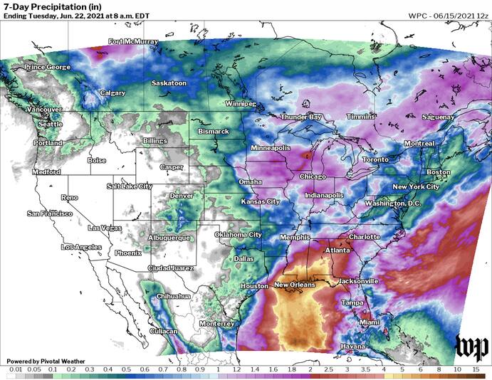
The @NWSWPC is highlighting the risk of very heavy rain for the northern Gulf Coast in association with whatever entity comes out of the Gulf of Mexico late week. That 7” contour runs from south-central Louisiana to NW Florida with a 10” peak! pic.twitter.com/EJvsCFI1HM
— Eric Blake 🌀 (@EricBlake12) June 15, 2021
That region of the Deep South and Gulf Coast has seen exceptional rainfall in the past several months, including several waves that prompted flash flood emergencies in Baton Rouge and Lake Charles in mid-May. Baton Rouge has seen 31.63 inches since April 1, with 28.96 inches in Lake Charles. New Orleans is closing in on 30 inches as well, and a few locales have exceeded three feet.
Much of the Interstate 10 and 20 corridors will be at risk for instances of flooding, with several inches of rain even possible in Atlanta. By late Monday or Tuesday, what remains of the system could reach the Carolinas or even farther north into the Mid-Atlantic.
It is unlikely that any incipient depression or storm would later make a run at hurricane strength, but a tropical storm is certainly a possibility. At this point in the season, Gulf of Mexico waters haven’t warmed sufficiently to sustain a higher-end system.
Additional tropical systems

Meanwhile, two other systems bear watching. Tropical Storm Bill was named northeast of the Outer Banks of North Carolina on Monday night, and as of 11 a.m. Tuesday was packing 60 mph winds as it raced northeast midway between Cape Cod and Bermuda.
The storm is predicted to lose its tropical characteristics by Tuesday night before slamming into southern Newfoundland on Wednesday morning.
A second system south of the Cape Verde islands is being monitored by the National Hurricane Center, and could attain some tropical characteristics as it churns over the open ocean. However, any meaningful development is unlikely.


