 Strange Sounds
 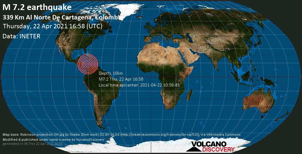 A major M7.2 earthquake was reported off Colombia on April 22 2021… Now, it has disappeared from the worldwide quake maps…
I started searching and found a new scientific study published on April 19, 2021 that actually reports about a shallow and fully locked part on the Caribbean subduction zone in Colombia capable of creating destructive earthquake and tsunami in the northwest region, off Cartagena.
Yesterday’s M7.2 ‘ghost’ earthquake happened exactly in the region where scientists predicted in the science paper.
This may be one of the reason why the powerful earthquake was deliberately hidden from the public. What do you think?
GPS data reveal earthquake and tsunami hazard in Northwestern Colombia
Now get your earthquake warning system…
Here a summary of the scientific paper:
Data from a GPS network in Colombia have revealed a shallow and fully locked part on the Caribbean subduction zone in the country that suggests a possible large earthquake and tsunami risk for the northwest region.
The locked patch south of Cartagena city is capable of generating a magnitude 8.0 earthquake every 600 years, said Sindy Lizarazo of Nagoya University in Japan, who presented the study at the Seismological Society of America (SSA)’s 2021 Annual Meeting.
Colombia lies in the middle of a complex tectonic zone, where the Caribbean, Nazca and South American tectonic plates and other smaller tectonic blocks converge. The Caribbean plate is very slowly converging with the northern part of Colombia — moving at 7 millimeters per year — which may in part be the reason for the long time between large earthquakes in northwest Colombia.
“The only recent historical record of a disastrous [magnitude 6.4] earthquake in the Colombian Caribbean region was on May 22, 1834 close to Santa Marta,” said Lizarazo. “However, there is no seismic event that meets the magnitude estimated by our study, nor tsunamis in the historical record on the northern part of Colombia.“
To better understand the complex movements and crustal deformation taking place in the region, Lizarazo and colleagues analyzed data from the nationwide GPS network called GeoRED (GEOdesia: Red de Estudios de Deformación in Spanish). The network has been operated by the Geological Survey of Colombia since 2007 and has 150 permanent stations in continuous operation.
GPS data can be used to estimate the movements and crustal deformation of the tectonic plates interacting against each other. The data analyzed by Lizarazo and colleagues revealed motion of the northern part of the North Andean Block — a “microplate” squeezed between the Nazca and South American plates — that causes it to interact with the subducting Caribbean plate.
Using these data along with a realistic slab configuration, the researchers estimated the extent and degree of interplate locking along this boundary, where stresses may build without being released in an earthquake.
The study “provides the first evidence of a shallow locked region south of Cartagena,” Lizarazo said. “This indicates that this segment of the Caribbean-South America plate boundary in northwestern Colombia can be the locus of significant earthquake and tsunami hazard.“
To fully evaluate this hazard potential, researchers need to conduct large-scale geological mapping, and look for evidence of past tsunamis and large earthquakes in the region, among other studies. “It is also necessary to continue with the densification of the GPS network in the country, increasing its coverage and operation in real time,” Lizarazo said.
This is clearly the main reason why the powerful earthquake was deliberately hidden from the public. What do you think? [SSA, ScienceDaily]


