 The Watchers
 BY THE WATCHERS
South Africa has declared a National State of Disaster due to the widespread impact of floods in several provinces, which have caused the loss of lives, severe damage to infrastructure, and affected homes and businesses. The flooding was brought by heavy rain affecting the region since February 8.
The heavy rainfall was produced by a cut-off low-pressure system that developed over the western interior on Wednesday, February 8, 2023, before moving into the central interior where it became quasi-stationary from Thursday until Saturday, February 11 before dissipating on Sunday.
The South African Weather Service (SAWS) reported that ample tropically sourced air was advected southwards from northern Namibia and Botswana, where significant rainfall had occurred lately due to the presence of a tropical low called an ‘Africane’. Cut-off lows are notorious for causing severe weather over South Africa, such as heavy rainfall and flooding.
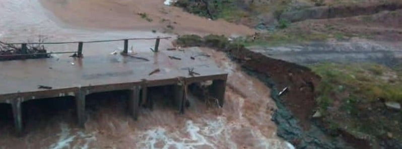
The extreme rainfall resulted in widespread flooding, with major rivers, especially those transiting the Kruger National Park and Lowveld, being in a full flood since the beginning of the weekend. The Escarpment and Lowveld regions of the Limpopo province and particularly the Mpumalanga province have borne the brunt of the flooding, with the southern half of the Kruger National Park particularly affected. Many low-water bridges and causeways, including the Crocodile bridge and the causeway at Lower Sabie camp, are flooded, while numerous main roads, including the main road linking Skukuza to Lower Sabie, are closed due to flood damage.
Furthermore, an additional low-pressure system over southern Mozambique and northern KwaZulu-Natal (KZN) significantly elevated the risk of flooding along the KZN coastline for Saturday night, prompting the South African Weather Service to broaden the Orange Level 9 Impact-Based warnings to include a significant portion of eastern KZN.
Overnight measurements of rainfall revealed that Charters Creek in KwaZulu-Natal received 242 mm (9.5 inches) during Saturday into early Sunday morning while Tshivhasie Tea Estate in Venda in Limpopo received 294 mm (11.6 inches) on Friday into Saturday morning.
Despite the cut-off low having weakened significantly, there is a fresh rain system currently moving into Zimbabwe today from the east, expected to move westwards in the coming days.
This system is a so-called east wind wave and is likely to herald a further episode of persistent and sometimes heavy rain for the northeastern and northern provinces, which are already saturated and rain-soaked following the heavy rainfall of the past week. An easterly wave is a tropical phenomenon, where tropical easterly flows result in disturbances that bring rainfall over the northeastern regions of South Africa. These waves in the lower atmosphere are usually associated with the Inter-Tropical Convergence Zone (ITCZ).
Home | Caravan to Midnight (zutalk.com)


We need your help to keep Caravan to Midnight going,
please consider donating to help keep independent media independent.