 Strange Sounds
 When I wrote my first article on billionaire bunkers years ago, I never would have imagined how quickly our world was changing. Our lives are in a constant state of flux, the political situation aside, our earth is rapidly changing. Between the increase of bizarre weather patterns hitting the earth, and recent major volcanic activity, now more than ever our focus is on our planets future.
Gordon-Michael Scallion vision
In the early 1980’s, spiritual visionaries and futurists provided clues to our changing planet. Often dismissed as crazy prophets, their thoughts for a new world were quickly ignored and laughed at. Gordon-Michael Scallion was a futurist, teacher of consciousness studies and metaphysics and a spiritual visionary. In the 80’s he claims to have had a spiritual awakening that helped him create very detailed maps of future world, all stemming from a cataclysmic pole shift. The result, while not based on any science, nonetheless provides a vivid and compelling picture of an Earth ravaged by flooding.
Scallion believed that a pole shift would stem from Earth Changes, nuclear activity, and the misuse of technology. Another theorist and psychic Edgar Cayce predicted that when both Mt. Etna volcano in Italy and Mt. Pelee in Martinique erupt together, there will be approximately 90 days to evacuate the west coast before the massive flood claims the coastline.
https://youtu.be/Xy74wZyPsb8
Asteroid and comet collision
But the most compelling argument is that an asteroid or comet collision with earth could cause the entire planet to shift.
According to a NASA report, “Many doomsday theorists have tried to take this natural geological occurrence and suggest it could lead to Earth’s destruction. But would there be any dramatic effects? The answer, from the geologic and fossil records we have from hundreds of past magnetic polarity reversals, seems to be ‘no.’ There is nothing in the millions of years of geologic record to suggest that any of the doomsday scenarios connected to a pole reversal should be taken seriously.”
If this was true, why did you launch the NEOWISE Mission to document potentially hazardous near-Earth objects? Why did you create an Asteroid watch website? Why have you started a mission whose main goal is to deflect the trajectory of a near-Earth asteroid named 2008 EV5? Probably because you are scared, no?
And what about cataclysmic earthquakes causing a planetary shift and coastal flooding? Oh yes, like Cascadia… Well maybe it is far more likely an asteroid hit would cause a polar shift. But they could also lead to cataclysmic change and maps similar to Scallions original vision.
With all of this knowledge of future mapping, do the world’s financial leaders know something we don’t?
Consider how many of the richest families have been grabbing up massive amounts of farmland around the world. All property is far away from coastal areas, and in locations conducive to self-survival, farming and coal mining.
It appears that dry territories in the United States such as Montana, New Mexico, Wyoming and Texas are all very popular regions for the wealthiest individuals. Billionaires such as John Malone (currently the largest landowner in America, owns 2,200,000 acres including Wyoming and Colorado), Ted Turner (2,000,000 acres in Montana, Nebraska, New Mexico and North Dakota), Philip Anschultz (434,000 acres in Wyoming), Amazon’s Jeff Bezos (400,000 acres in Texas) and Stan Kroenke (225,162 acres in Montana) all have amassed major land. Upon further research, many billionaires are preparing for future escape plans with “vacation homes” in remote locations. Many of them also have their private planes ready to depart at a moment’s notice.
Billionaire Bill Gates recently acquired 28,000 acres in Arizona to create his own city called Belmont. According to the company announcement; “Belmont will create a forward-thinking community with a communication and infrastructure spine that embraces cutting-edge technology, designed around high-speed digital networks, data centers, new manufacturing technologies and distribution models, autonomous vehicles and autonomous logistics hubs.” The company details the plans including; 3,800 acres for office, commercial and retail space, 470 acres for public schools and there are plans for 80,000 residential units. “Belmont will transform a raw, blank land into a futuristic city built around a flexible infrastructure model” added Belmont Properties.
Even a wealthy member of the Mormon church, David Hall reportedly had plans for 20,000 person self-sustained communities throughout the country, including the first in Vermont with a recent 900-acre farmland purchase. The communities would have been called NewVistas, but local opposition killed the development plans.
Internationally, moguls in Australia and New Zealand have been snapping up farmland at record paces. The interest in cattle, dairy and agricultural farms are all proving tempting for self-sustained survival. But more importantly the wealthy are preparing for safe escape havens, stockpiling real estate in dry areas and moving away from the old-school approach of storing food and water. Money and precious metals will be useless, as self sustainable territory will become the new necessary luxury. Many have installed helipads on their properties for easy access and many are buying up Silos and bunkers around the world.
So, in the event of a post asteroid apocalypse, where are the safest territories in the world?
According to several prognosticators and much criticized theorists, here is the detailed list of predicted land changes based on geological positioning. All post polar shift predictions are based on theories from Gordon-Michael Scallion, Edgar Cayce and others, and should not be construed as fact.
Africa
Africa will ultimately be divided into three parts. The Nile will widen significantly. A brand new waterway will split the entire area, from the Mediterranean Sea towards Gabon. As the Red Sea enlarges, Cairo will ultimately disappear into the sea. The majority of Madagascar will also be taken by the sea. New land will then rise in the Arabian Sea.
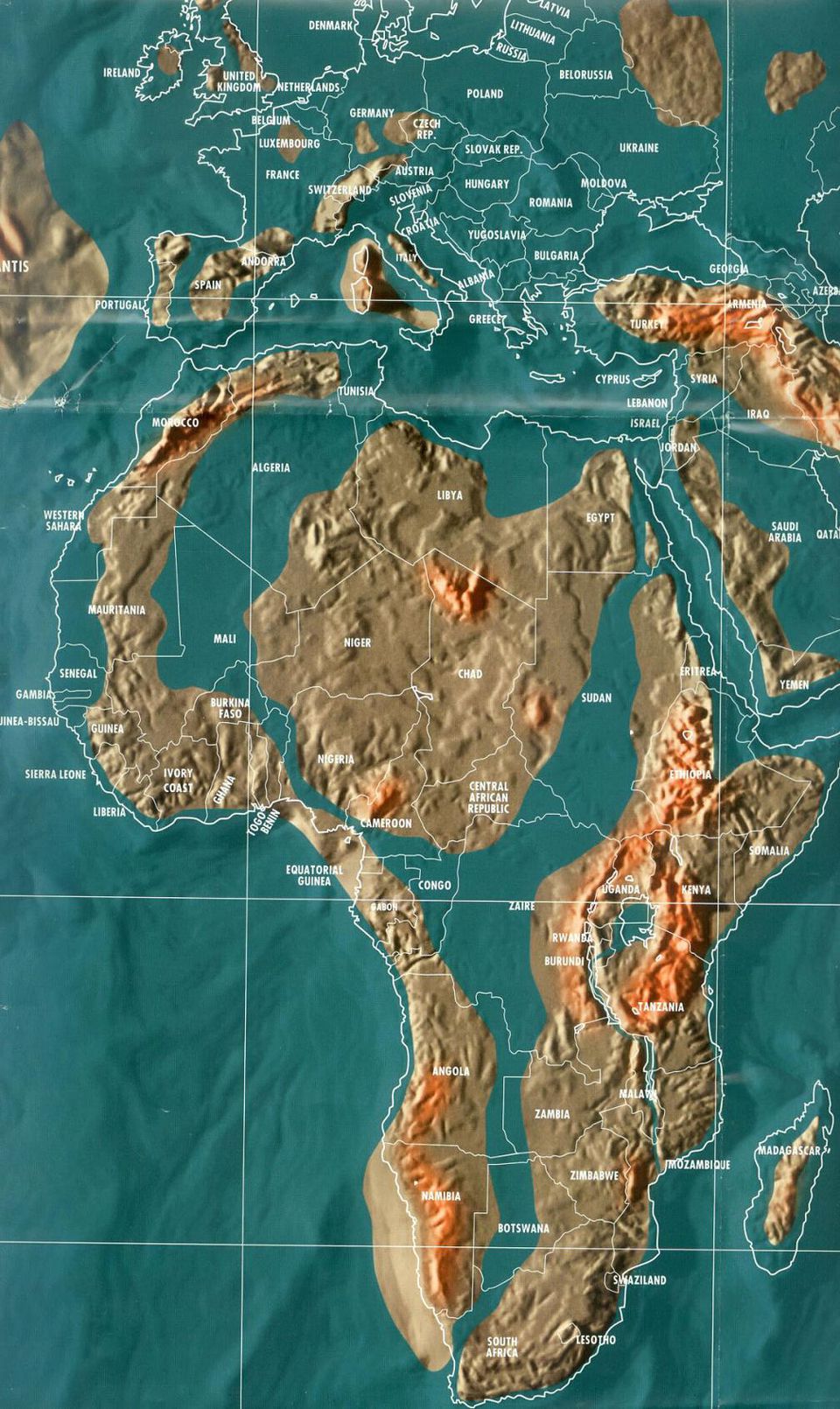
A new landmass will develop to the north and west of Cape Town, and new mountain ranges will be emerge above ground in the area. Lake Victoria will merge with Lake Nyasa and flow into the Indian Ocean. Central eastern Africa’s coast-lines will be completely inundated by water.
Asia
This heavily seismic region will have the most severe and dramatic Earth changes. Land will be inundated from the Philippines to Japan, and north to the Bering Sea, including the Kuril and Sakhalin Islands. As the Pacific Plate shifts its position nine degrees, the islands of Japan will eventually sink, leaving only a few small islands.
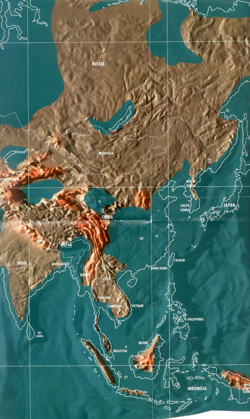
Taiwan and most of Korea will be completely lost to the sea. The entire coastal region of China will be pushed inland hundreds of miles. Indonesia will break up, however some islands will remain and new land will emerge. The Philippines will disappear completely beneath the sea. Asia will lose a significant amount of its land mass through these dramatic changes, however entirely new land will eventually be created.
India
Due to extreme land buckling and lowering the elevation of the country, the population of India will be told not to seek higher ground within the interior country, but to head to the Himalayas, to Tibet and Nepal and China or the higher mountains that are officially with Indian territory.

Antarctica
Antarctica will become fertile, soil rich and farming territory. New land will be created from the Antarctic Peninsula to Tierra del Fuego, and east towards South Georgia Island.
Australia
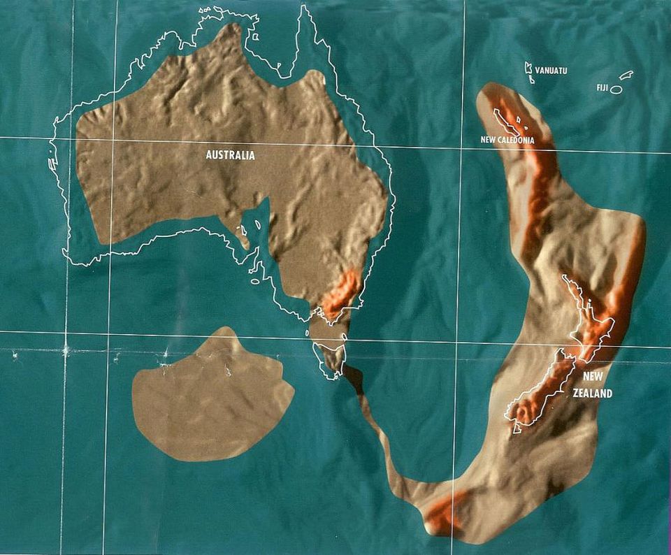
Australia will lose nearly twenty-five percent of its land due to coastal flooding. The Adelaide area will become a new sea all the way north towards Lake Eyre.
The Simpson and Gibson Deserts will eventually become fertile, farming land. Entirely new communities will develop between the Great Sandy and Simpson Deserts and new refugee settlements will be created in Queensland. New land will also be created off the coast.
New Zealand
New Zealand will grow in size, and will once again join the land of old Australia. New Zealand will quickly become the glory land, and ultimately become one of the safest areas in the entire world.
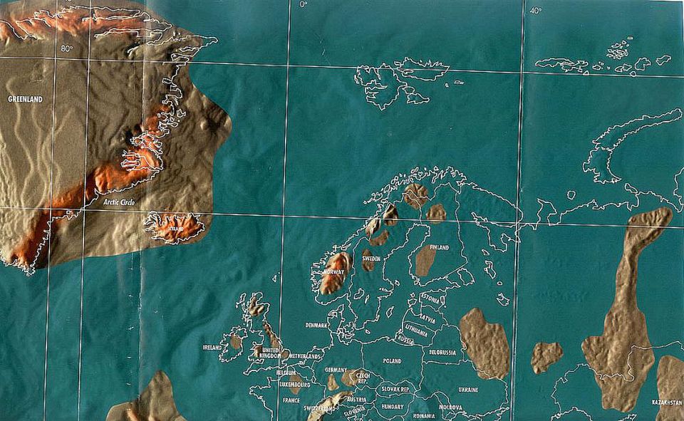
Europe
Europe will experience the fastest and most serious Earth changes. Most of Northern Europe will sink beneath the sea, as the tectonic plate underneath it collapses. Norway, Sweden, Finland, and Denmark will be all disappear and will ultimately create hundreds of small islands.
Most of the United Kingdom, from Scotland to the English Channel, will disappear beneath the sea. Several small islands will remain. Major cities like London and Birmingham will be among the remaining islands. Much of Ireland will disappear beneath the sea, except for the higher ground areas.
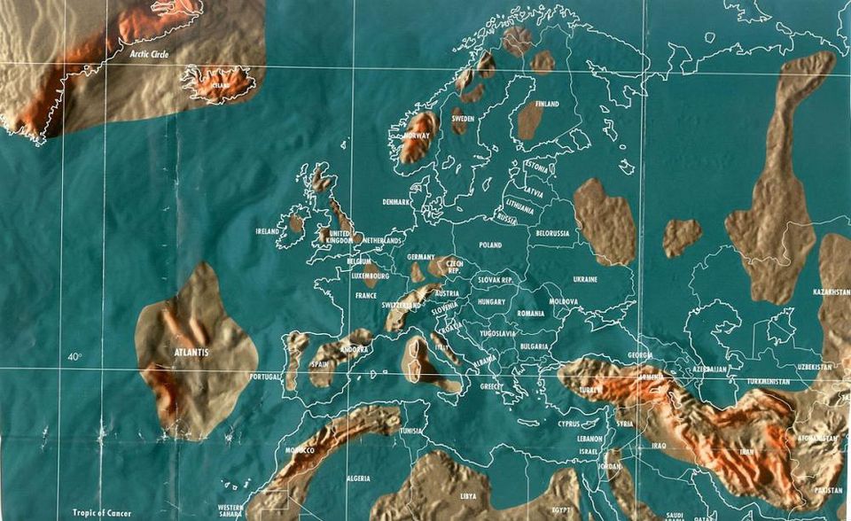
Russia will be separated from Europe by an entirely new sea when the Caspian, Black, Kara, and Baltic Seas combine. The new sea will stretch all the way to the Jenisej River in Siberia. The areas climate will remain safe, leaving Russia to supply most of Europe’s food. The Black Sea will merge with the North Sea as well, leaving Bulgaria and Romania completely under water.
Certain areas of western Turkey will go under water, creating a new coastline from Istanbul to Cyprus. Much of central Europe will sink and most of the land between the Mediterranean Sea and the Baltic Sea will be completely lost underwater.
The majority of France will go under water, leaving an island in the area surrounding Paris. A completely new waterway will then separate Switzerland from France, creating a line from Geneva to Zurich. Italy will be entirely divided by water. Venice, Naples, Rome and Genoa will sink below the rising sea. Higher elevations will be created as new islands. New lands will rise from Sicily to Sardinia.
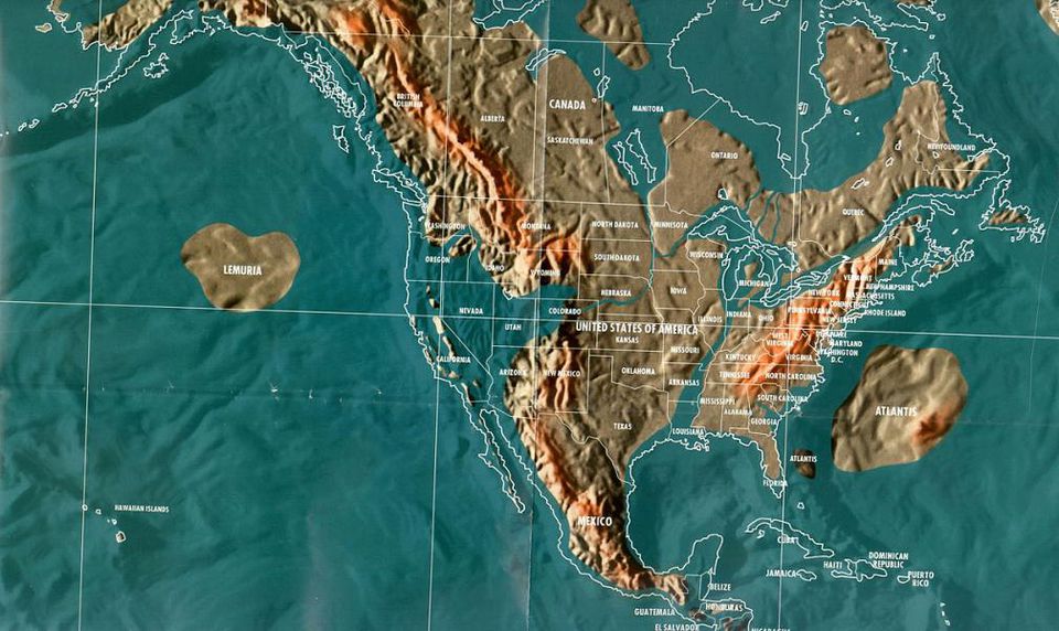
Canada
Parts of the Northwest region will be pushed in almost two hundred miles. Regions in Quebec, Ontario, Manitoba, Saskatchewan, and areas of Alberta will become the refugee / survival center of Canada. Most migrations into the region will arrive from British Columbia and Alaska.
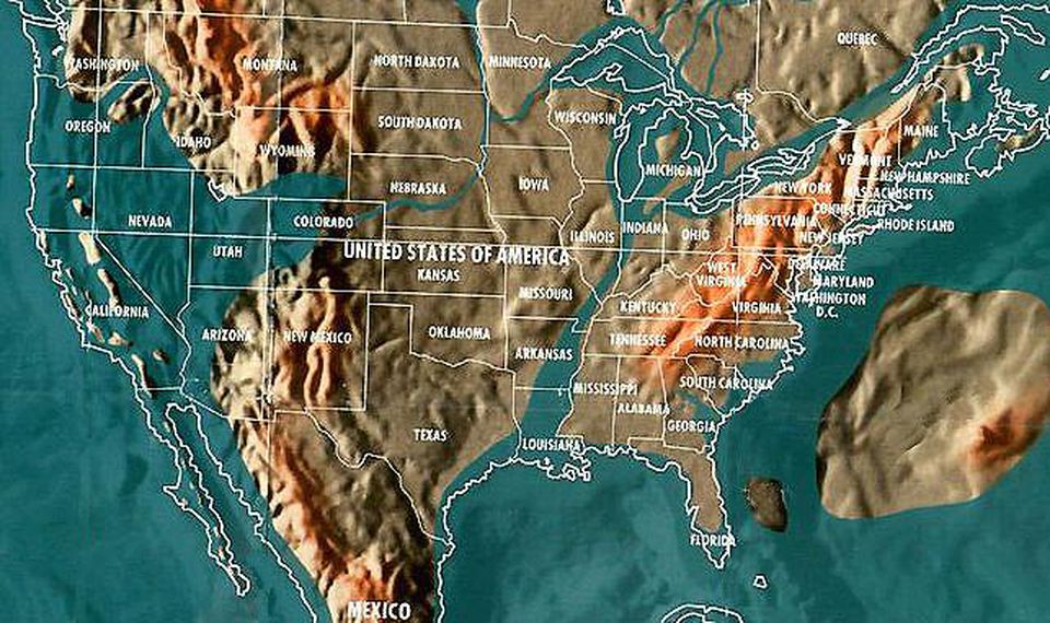
United States
As the North American Plate buckles, the new Islands of California will be created with almost 150 islands. The West Coast will recede east towards Nebraska, Wyoming and Colorado.
The Great Lakes and the St. Lawrence Seaway will join and continue through the Mississippi River to the Gulf of Mexico. All coastal areas from Maine to Florida will be taken over by water and pushed inland for miles.
Mexico
Most coastal areas of Mexico will be inundated far inland. The California Baja coast will ultimately become a series of islands. Much of the Yucatan Peninsula will be lost to the rising waters.
Central America and the Caribbean
Central America will sink and will be reduced to a series of islands. Higher elevations will be considered safe. A new waterway will eventually develop from the Bay of Honduras to Salinas, Ecuador. The Panama Canal will ultimately become cut off with no access.
South America
In South America, heavy earthquake and volcanic activity will take place. Venezuela, Colombia, and Brazil will be taken over by water. The Amazon Basin area will become a huge inland sea. Peru and Bolivia will be sink with rising waters.
Salvador, Sao Paulo, Rio de Janeiro and parts of Uruguay will sink below the sea, and so will the Falkland Islands. An entirely new sea will rise to take over much of central Argentina. A huge landmass, which will include another new inland sea will develop and join up with the land of Chile.

So now, like the billionaires that control the world, you can decide where you want to have a small parcel of land for the post-apocalypse. Always be ready and prepare for the worst… [Forbes]