by TYLER DURDEN
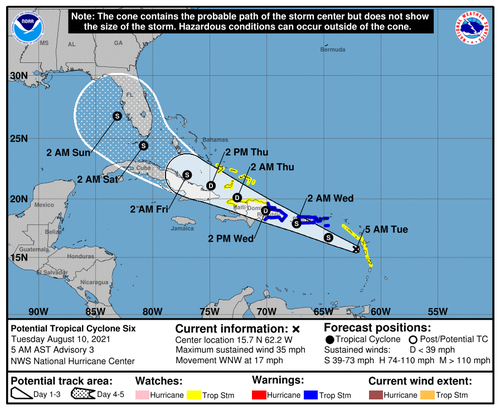
The National Hurricane Center is monitoring Potential Tropical Cyclone 6, which is set to become Tropical Storm Fred as early as Tuesday.
As of 0500 ET, Potential Tropical Cyclone 6 is 65 miles southwest of Guadeloupe, an island group in the southern Caribbean Sea. NHC states the storm has a 90% chance of developing into a tropical storm over the next 48 hours.
WFTV Orlando’s Meteorologist Brian Shields expects Potential Tropical Cyclone 6 to be upgraded to Tropical Storm Fred “soon.” He expects the storm will soon “impact Puerto Rico as a tropical storm, and then move into the Dominican Republic.”
BECOMING FRED: This will become Fred soon. It will impact Puerto Rico as a tropical storm, and then move into the Dominican Republic. If it survives land, there could be a tropical storm just south of us by late week. I'm tracking what all this means, on Channel 9 right now! pic.twitter.com/5Y0bN37umn
— Brian Shields (@BrianWeather) August 10, 2021
By the weekend, Shields expects the storm could impact the South Florida area. NHC’s forecast cone shows the storm could begin to produce tropical storm conditions in South Florida as early as Saturday morning.
The National Weather Service said Monday that South Florida could see “widespread and heavy rain” over the weekend. The impact of the storm is still unclear.
Aug 9th at 5pm – Potential Tropical Cyclone Six is forecast to become a Tropical Storm later tonight. While exact impacts for South Florida remain uncertain at this time, widespread & heavy rain will be possible across South Florida late this week into this weekend. Stay tuned! pic.twitter.com/J4t50HZxLA
— NWS Miami (@NWSMiami) August 9, 2021
A Tropical Storm Warning is in effect for:
- Puerto Rico, including Culebra and Vieques
- U.S. Virgin Islands
- Dominican Republic on the south coast from Punta Palenque
- eastward and on the north coast from Cabo Frances Viejo eastward
A Tropical Storm Watch is in effect for:
- Martinique and Guadeloupe
- Dominica
- Saba and St. Eustatius
- Dominican Republic on the north coast from Cabo Frances Viejo to
- the Dominican Republic/Haiti border
- Haiti from the northern border with the Dominican Republic to
- Gonaives
- Turks and Caicos Islands
- Southeastern Bahamas
Last week, the National Oceanic and Atmospheric Administration upgraded the number of named storms this year to 21 from its prior forecast of 15 in May.
Statistically, the busiest part of the hurricane season begins on Aug. 20 and lasts through Sept. 10.


